(Prior posts on Krakit here.)
I’m not breaking open the envelope on Krakit just yet — let’s say, in a few days? — but we had some industrious commenters at least make plausible stabs at Clues 6 and 11, and I have my own half-way plausible guess on 12. That makes at least a non-random guess on every single answer.
The general theme for all three possible answers is assuming something about the answer, which plausibly resolves into country-town-number, and waving over the fact some of the clue never got used.

Inside the ZX81. Public Domain.
For Clue 6, I was trying to decipher the text that was there, assuming hexadecimal (from “Curse” and the fact the letters go up only to F). Adam Sampson suggested to look at the digits that were not given.

Namely, read directly in order, the missing digits are 49BCE, a year which very strongly associated with a particular event: Caesar crossing the Rubicon. The modern day city this was thought to be at is Savignano, Italy.
Could this really be the solve? What does the “half” part mean? What’s going on with the blacked-out squares? The “half” could refer to the blacked-out half, so does that mean the missing part of the text has the digits 4, 9, B, C, E in some amount of repetitions and order? If so, where does the hex code as a whole comes from?
I will say it seems like a major coincidence to have the left-out digits spell out a coherent date which leads to a clear answer.
(I very vaguely suspected it has to do with the code of the Krakit software itself, making for a super-meta puzzle which leverages the medium and makes it not quite a glorified slideshow, but I don’t have a good way of checking how it gets stored in ZX81 memory — it isn’t equivalent to the modern emulator tape file.)

Clue 11 (above) had another “skip”, this time from redhighlander:
HEAR GREEN BALLAD is an anagram for Ballaghaderreen, where William Partridge died. He was part of the Easter Rebellion, which took place in 1916.
So, I would say Ireland (country), Ballaghaderreen (city), 1916 (number).
That’s one serious anagram-coincidence, there, so I’m willing to call this one definite except for the number. We’ve skipped the MU/SL/IN/REST bit entirely, as well as “That is 3”.
For 12, I’ve spent the last couple days tormenting myself in various ways.

My initial assumptions were:
a.) the stars are the only asymmetrical part, so they are important
b.) they likely indicate, in some indirect way, letters/numbers that we can decipher
This wasn’t going anywhere, so I decided to go for the skip. Let’s assume instead
a.) the “packed area” contains letters that we are supposed to anagram (some indicator I haven’t figured out narrowing down which letters, but let’s just try with all of them)
b.) as Carl Muckenhoupt observed, the character repeated in the middle might not be a zero, but a letter ø
c.) the LANDICEHAIL on the top is not meant as a deception, but is rather a clue.
d.) the stars are just “snow” and can be ignored
Putting all these things together, I managed to get Tromsø, Norway, and the number thirteen.
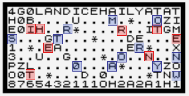
I don’t feel the slightest bit confident in my answer, but it is true the clues that have “spelled out” the answer (1, 8) have included both country and city, so the letters need to include both. Is there some pattern involving the numbers along the top/bottom that makes this all make sense? Since I can technically switch THIRTEEN out for ZERO and have all the letters for it even if my skip is correct I have to coin flip which one of those is right.
At least I have something I can fill out the entire contest entry form with, so we’ll at least have a chance (however small) of “winning”. Please post any extra feedback or alternate solves, and if something is better I’ll adjust accordingly.
One quick general plea: can someone figure out exactly how many bridges Budapest had between Buda and Pest in 1982? Just a naive Wikipedia check gets 6, but that’s a list of “most famous” bridges.

This map (https://www.flickr.com/photos/nat507/8452342378) appears to be from 1982 and shows four bridges across the Danube. However, the Petöfi híd is not on there (too far south) but it had already existed since 1952. And then there is the Árpád híd (too far north) which was built in 1950. However, there is also the Újpesti vasúti híd (too far north) for trains. If my count is correct that makes seven: four shown on the map and three that should be there but aren’t due to the size of the map section.
The other four bridges were built much later than 1982; nowadays, there seem to be eleven of them.
7 sounds good, I’ll put it in as the number.
(Btw, one of the annoying things is that the rules specify the numbers are from 1 to 6 digits long, and we have two answers that are a single digit — this one and Two Gentlemen of Verona — but none that make it up to 6. I can’t even think of, given one of the numbers we have is wrong, which one it’d be; there’s a fair number of dates. In a really well-designed contest there would have to be an answer that is 6 digits, but I’m not convinced this is well-designed.)
Repeating what I said from the thread, MU/SL/IN/REST gets you kind of close to Ulster, Leinster, and Munster, three of the four provinces of Ireland, and the fourth province is Connacht, where Ballaghaderreen is. So that seems pretty solid.
The other two… boy I don’t know.
any idea what the 2, 2, 2, 3 thing is though? do provinces have sub-provinces or “counties” or some such?
(add: counties, the numbers don’t match. dunno then. maybe something only true on a historical map of the year the rebellion happened?)